|
MapsKit32 is a graphical maps system for real time management
of security and safey installations
(intrusion, fire detection, gas detection, CCTV)
It's based on 32 bit Windows (Win 9X, Me, NT/4, 2000 e XP)
PCs and on specific hardware components.
The windows based visualisation gives facilities to report
on graphical maps (i.e.: building plants)
the signalisations coming from installation, in a very intuitive
and immediate way.
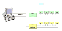
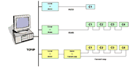
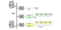
There are two different system typologies:
- MapsKit32S (serial version) for a maximum of 8 panels
and a single operating point (PC).
- MapsKit32/S: mixed solution
- MapsKit32Net (TCP/IP net) for multiple panels and multiple
operating points (PCs)
 |
|
Graphical
maps construction module: MapsGen32. |
| |
MapsGen32 module allows, across a convivial graphical
interface and the usual tools of Windows, construction
of the hierarchical tree
structure of graphical maps.
Form a main map is possible to navigate
down the tree on sub maps on wich are positioned the
point control (detectors).In case of alarm, Mapskit32
switches directlly on the map on wich are positioned
the alarmed detector.
|
|
click to enlarge
|
|
|
 |
|
Events and alarms
management |
| |
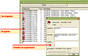
The events that
occour in the system are classified in different levels
with different meaning and priority and are memorized
in an on-line real-time updated archive.
The user can select, inside different alarm levels,
that will active acoustical signal of PC or not.
Furthermore, there's the possibility to acknowledge
one or all of pending alarms |
|
click to enlarge
|
|
|
 |
|
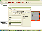
Panels
management |
| |
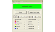
A specific form for each panel in the system allows
reporting status and sending command.
The details of this form depend from the type end model
of the panel
|
|
click to enlarge
|
|
|
|